|
Let's Talk Sanborn Maps
By Alana Coons
January/February 2022
 Courtesy Library of Congress |
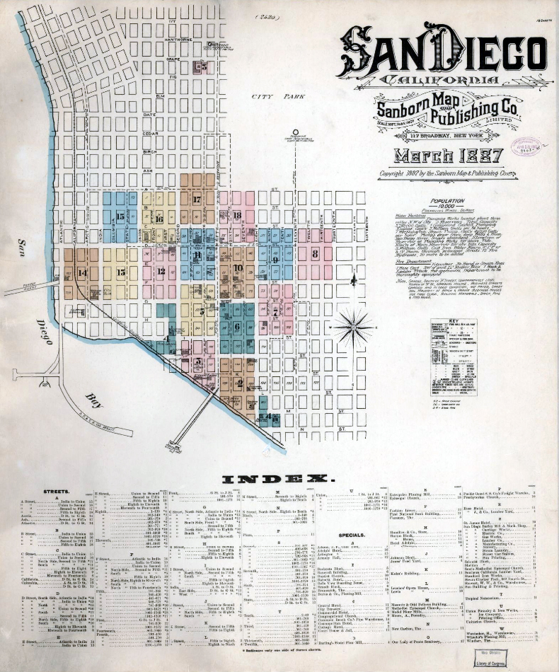
Welcome to the helpful and fascinating world of Sanborn maps! Created originally for the fire insurance industry for risk assessment purposes (1867-1970), Sanborn Fire Insurance Maps (Sanborn Maps) contain a wealth of information on building features, such as size, shape, the number of stories, construction type, use (sometimes by room), and street address. Lot numbers or addresses can help with accessing deeds and other civil records.
Each Sanborn map is a block-by-block snapshot in time, generally of the historic or central business district of a city. They are particularly useful if Sanborn mapped the city more than once; an earlier map can be compared to a later one. Because many buildings are modified over time, the maps make a handy tool for evaluating a structure's significance. The last original Sanborn map was made 60 years ago, and the last update occurred 44 years ago, so any change recorded on the maps is likely to be at least 50 years old now.
For basic documentation, Sanborn maps provide a solid and credible source, and often the best source available, especially if no good photographic and/or permit history exists for a building. These detailed and comprehensive maps enable historians, preservationists, property owners, architects, urban planners, and others to understand the importance and historical evolution of buildings, including their historic uses and building materials, for conservation, and restoration and rehabilitation.
If sequential, the maps show in simple diagrams what, if any, changes to a potentially historic structure have occurred as well as building progression, such as the extension of a porch, room additions, or the loss of outbuildings.
Within the outlines of each building and outbuilding, you'll also find the location of windows and doors; street names; street and sidewalk widths; property boundaries; fire walls; house and block numbers; building materials, including framing, flooring, and roofing; and much more. They can narrow the date when a building was constructed and help chart remodels and demolition.
While Sanborn maps are generally accurate and consistent across different years, you may find some minor discrepancies. These usually result from differences in mapmaking rather than changes to a building. Details such as exact building dimensions, presence or absence of a bay window, or roofline height may vary slightly from one year to another without reflecting any actual change to the building. Also, the original map page will show the pasted-on changes over the years. The pasted layers are less apparent in digital copies, so use paper maps, if available.
Sanborn maps are but one tool in the architectural researcher's tool box and should be used along with other available information, such as historic photographs and renderings to confirm building details.
If you have a San Diego Public Library card, you can access local Sanborn maps HERE. Scroll down and click on the History & Genealogy tab, then scroll down to Sanborn Fire Insurance Maps - California. These maps of 573 cities and towns were made 1867-1970.
The national collection of original Sanborn maps, bound by city and organized by year, is housed at the Library of Congress and available online.
We also recommend this great podcast!.
Learn more about researching a historic house or building.
|
2025
2024
2023
2022
2021
2020
2019
2018
2017
2016
2015
|